Last updated on 10/30/2025
Water Quality
Water Quality includes a program of real-time telemetry, generally with 15-minute reporting to the California Data Exchange Center. In addition, the SJRRP initiated a program of manual water quality constituent measurements.
Real-time Telemetry
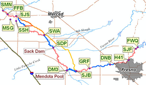
| CDEC Station | Temperature | EC | DO | Turbidity | pH | Chlorophyll |
|---|---|---|---|---|---|---|
| FWQ - At Friant Dam | FWQ | FWQ | FWQ | FWQ | FWQ | FWQ |
| SJF - Below Friant | SJR | SJF | ||||
| H41 - Highway 41 | H41 | H41 | ||||
| DNB - Donny Bridge (Rd 32) | DNB | DNB | ||||
| GRF - Gravelly Ford | GRF | GRF | GRF | GRF | GRF | GRF |
| SJB - Below Bifurcation | SJB | SJB | SJB | SJB | SJB | SJB |
| DM3 - Delta Mendota Canal Check 21 | DM3 | DM3 | ||||
| SDP - Near Dos Palos | SDP | SDP | SDP | SDP | SDP | SDP |
| SWA - Washington Road | SWA | SWA | SWA | SWA | SWA | SWA |
| SJS - Stevinson | SJS | SJS | ||||
| SSH - Salt Slough | SSH | SSH | ||||
| FFB - Fremont Ford Bridge | FFB | FFB | ||||
| MSG - Mud Slough | MSG | MSG | ||||
| SMN - Near Newman | SMN | SMN | SMN |
Measurements
In addition to the gaged stations described above, the SJRRP took measurements of water quality parameters at a variety of additional locations.
Temperature Atlas
- (pdf, 7.2 MiB)
- (pdf, 41.3 MiB)
- (pdf, 4.0 MiB)
- (pdf, 13.7 MiB)
- (pdf, 9.1 MiB)
- (pdf, 7.4 MiB)
- (pdf, 10.1 MiB)
- (pdf, 5.9 MiB)
- (pdf, 3.4 MiB)
- (pdf, 12.0 MiB)
- (pdf, 8.0 MiB)
- (pdf, 7.1 MiB)
- (pdf, 2.7 MiB)
- (pdf, 14.6 MiB)
Water Quality Measurements
SJRRP measurements of total suspended solids, EC, pH, Turbidity, DO, bacteria, trace elements and pesticides at eight sites have been added to the Bureau of Reclamation Water Quality Database. Query All Program Information, Station Description field for “Interim Flows”.
Monitoring is organized according to the Interim Flow Water Quality Monitoring Plan.